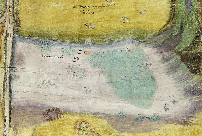
The ca. 1738 painted map of the “Pickmore Poole” (Burlington Pool, SJ780110), near Sherrifhales
We are indebted to Dr Andrew Pattison for bringing this fascinating map to our attention, in June 2014. Andrew found it in the Shrewsbury Archive, document SA–972–7–1–33, endorsed “supposed 1738” and we acknowledge the permission of the Archive to reproduce it here.
We now (2016) have a high-resolution image of the original map, which appears to be on vellum, reproduced here at a lower resolution to give the context of the pool. We also give several close-ups of the pool and parts of it.
NOTES on the whole map. To read it, it help to turn parts of it upside down.
- The map is oriented with north to the right and the road on the left, and labelled ‘Wattling Street’, is the current A5, which runs east to west.
- The track heading north, to the west (on the right), is labelled the ‘Chester High Way’, the current A41.
- Along Chester High Way is a small enclosure labelled ‘The Conie[dg?le’ – conie being rabbit and nine, of various colours, are shown. ‘The Lodge’, east of the conie enclosure, may be the current Lodge Farm at SJ791118.
- Further north on the A41, past the conies, is a cowman herding nine beasts southwards.
- To the east of the pool is ‘The Common [in Queftion] The Hide’, with ten sheep grazing. Further east of is the north-heading ‘The Kings High Way’ while further east again is labelled the hamlet ‘Burlauton’ (now Burlington) seemingly with many more houses than currently represented in the 1:25,000 OS map.
- In the extreme NW (top right) is a church with a tower labelled ‘Hales’, the distance out of scale but it has to be the church in Sheriffhales, actually 2km distant.
- Equally out of scale and in fact 2km east (bottom right) is shown the church and ‘Wefton Hall’ at Weston-under-Lizard. A windmill, ‘Mitton=s Mill’ is shown on the way there on the north side of Wattling Street, the latter not now mapped though a small hill at SJ797112, ‘The Mount’, might be the spot.
- The ‘White Sitch’, still bearing that name, is the lake at SJ790125, currently surrounded by woodland.
A few wildlife-related notes on Pickmore Poole are appropriate though how much of the detail is reality and how much the imagination of the surveyor/illustrator is impossible to judge, nearly thee centuries on. Mouse-over the image above to see the numbered items listed below.
- The large bird floating in the lake has to be a Mute Swan, with another (also with red on the bill) on a nest on the island.
- The two birds standing on what is the NE margins of the lake are rather striking and are most unlikely ever to have occurred there. The long red bills suggest White Storks while the extravagant tails suggest Cranes. Dr Pattison suggests the following; “… if our artist (who is likely to be the agent of the landowner) had any Dutch influence, which was popular at the time, he could have picked up the storks that way” adding them to embellish his map.
- The animal on the water, pursuing the five ducks, is a dog.
- There is a representation of either a small trap or cage on the SE shore of the lake, certainly not a duck decoy, which would have involved the entire pool. See Addendum.
The Mute Swan and ‘White Storks/Cranes” are species indexed within Histo.
*Addendum: 25 February 2016.
In Duck decoys: stars of the pond landscape, Heaton, A. (2016). British Wildlife. 27(2)162-170, Andrew Heaton writes “… Midland estates in fact had a preference for a different type of duck trap, worked directly with sliding doors controlled by wires”. The Pickmore contraption could be interpreted as such a trap.


The ca. 1738 painted map of the “Pickmore Poole” (presumed to be Burlington Pool, SJ780110) area, near Sherrifhales.
We are indebted to Dr Andrew Pattison for bringing this fascinating map to our attention, in June 2014. Andrew found it in the Shrewsbury Archive, document SA–972–7–1–33, endorsed “supposed 1738” and we acknowledge the permission of the Archive to reproduce it here.